Boom and bust.
Hi again everyone…
A very strong Nor’Easter is just south of Rockland, Maine, as of 4:45 PM this afternoon. A stiff northwest flow has been pouring across the state, and will be enhanced by a secondary boundary pushing through later this afternoon/evening. We do expect accumulating snows to continue over the Adirondacks, as well as over much of the rest of the state through roughly noontime Saturday. Accumulations outside of the Adirondacks will continue to depend highly on elevation.
It was mentioned both Wednesday and yesterday that one or both of a) a temperature variance of just a few degrees and b) a shift in the storm track … would have significant ramifications on our forecast. That has indeed been the case so far, as areas west of I-81 have seen quite a bit less in terms of snowfall than Delaware, Otsego, Schoharie, northern Herkimer, Hamilton, etc. Elevation has won the battle… valley floors have very little accumulation while the hills are seeing the brunt of the wet snow. We’ve had reports as well in the valleys that what has fallen has already melted.
Things could get quite icy tonight. Temperatures are starting to drop, especially across the western part of the state. This will continue tonight… and by time you get up in the morning we’ll be looking at temps in the lower to middle 20s just about everywhere, with mid to upper teens across the Adirondacks. So areas that are just wet right now will turn to ice tonight; roads that are wet right now will exhibit some freezing tonight. Traveling could get quite rough, especially in the higher elevations where more snow has fallen.
Winds get quite gusty tonight as our low continues to bomb off the coast. Northwest winds will average 15-25 mph, and may gust up to 40 mph at times, especially areas just southeast of Lake Ontario.
Saturday will feature blustery and cold conditions with occasional snow showers in the morning coming to an end. Winds will also die down during the afternoon. Areas of sunshine are expected during the afternoon… and while temperatures will be cold (upper 20s to mid 30s), that high sun angle means melting… will occur.
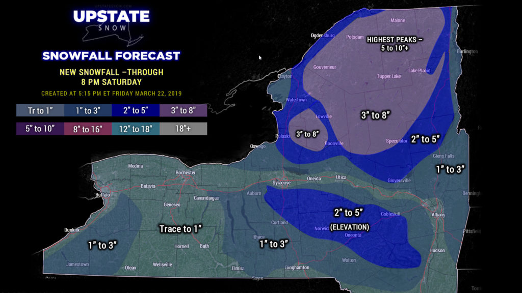
As far as new snowfall goes, through 8 PM Saturday — we’re still “in play” across the Adirondacks and Tug still…. yes we know that has busted a little bit so far, especially on the Tug, but we’re still going with an additional wide range of 3-8 inches. The higher peaks of the ADKs, while not “colored in,” will likely see 5-10+ as this storm continues to wind up and wander along the coast of Maine before pushing off to the north and east. Higher elevations of Onondaga, Madison, Cortland, Chenango, Otsego, Schoharie, and Delaware will be looking at an additional 2-5 as the “general” snows wind down to snow showers tonight, with 1-3 … or trace to maybe an inch elsewhere. The corridor Syracuse to Utica, as well as the Capital District southward, likely an inch or less… but someone might pick up 2 inches here or there. We’re also painting 1-3 for the Chautauqua Ridge as the wraparound moisture continues to drop snow showers tonight… upsloping will try to wring out a bit of extra moisture out of this, so we’ll go with some higher amounts there.

Another potentially icy night Saturday night as temps drop into the teens (ADKs) and 20s (everywhere else). Whatever has melted, will re-freeze…. but then melt A LOT on Sunday.
WILD temperature swings coming up over the next several days. On Sunday, high pressure builds to our south and east ahead of a cold front. Look for highs well into the 50s south of Lake Ontario and west of I-81, as well as from Albany southward, with generally mid to upper 40s everywhere else (upper 30s/lower 40s in the ADKs). As mentioned, a cold front drops from northwest to southeast across the state on Monday. This will bring some rain and snow showers (nothing significant), but temperatures Monday afternoon will be similar to what we see tomorrow… upper 20s to mid 30s. Those readings continue on Tuesday before another warmup begins next Wednesday and Thursday.
As far as the overall weather pattern… again… some rain and snow showers will accompany our cold front on Monday… before high pressure takes full control of our weather Tuesday through Thursday. Models show the next cold front arriving by Friday, with a renewed chance for rain.
As for riding: PLEASE check with local clubs before you head out tomorrow. Call ahead, check the Facebook pages and sites, etc. Conditions should be good across the Tug and the Adirondacks through much of next week… but call ahead just about everywhere else. WATCH THOSE LAKES!! Be very careful if you try to cross. Also… please respect landowners who may have closed up for the season.


