Ok GFS-FV3: You win.
Good evening everybody…
For several days the FV3 model has been INSISTENT that some kind of coastal storm would develop this week. For the longest time, it was a lone outlier while other models (the Euro especially) kind of flipped back and forth. Well, now we eat some crow as a fairly strong coastal storm will bring heavy wet snows to portions of the state Friday into Saturday. All of the operational models agree on this, with the Euro taking over as the strongest / coldest solution.
Here’s the “big picture”: High pressure slips off to our southeast tonight. A frontal system and weak area of low pressure will begin to approach from the west on Thursday morning, and with a south to southeast flow of moist air, look for showers to break out. This may be in the form of snow over the Catskills and Adirondacks early tomorrow morning, but by the afternoon it’s all rain. The original cold front tends to fall apart as it crosses the state Thursday afternoon; the strong southeasterly wind flow will rule. Meanwhile, low pressure is rapidly developing over eastern North Carolina. This will lift nearly due north… to a position over the Delmarva by tomorrow evening. By suppertime Thursday, a second, stronger cold front should be located over western NY. Rain should be fairly widespread across the state, with snows being confined to the highest elevations of the Adirondacks.
This stronger front crosses the state Thursday night into Friday as our coastal storm lifts northward to a position roughly along the Connecticut/Long Island coast. Cold air will start wrapping into the state on Friday, transitioning rain to snow across the higher elevations first… and eventually to the valley floors by Friday afternoon. As we move into Friday night, our coastal storm really strengthens… becomes a powerful Nor’Easter north of Cape Cod. Deep, cold air will wrap in on strong northwest winds and heavy wet snow should be occurring. The heaviest snow, whatever we get, should occur Friday afternoon into Friday night, with a gradual diminishing to snow showers late Friday night through Saturday.
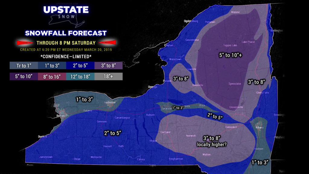
There are some pretty significant differences in the modeling as to how much snow we receive. This will be a classic elevation snowstorm, with fairly wide swings in amounts depending on your elevation. The European model is very aggressive with cold and snow, with widespread double-digit snow accumulations, especially in the higher elevations. The “main” GFS lies on the opposite end of this, with the FV3 somewhere in the middle. Remember… the FV3 was the only model that hinted at such an event in the first place.
But… Friday is March 22, Saturday is March 23. Something the models do NOT take into consideration. It’s super late season and we have a high sun angle — this is equivalent to it being September 22-23. Even with a cold atmosphere across the board, it’s going to be hard to get blockbuster accumulations down to the valley floors. Prior experience tells us that the highest elevations in the Catskills and Adirondacks could get crushed with a foot or more of snow by Saturday afternoon. The key words are COULD GET. There is a high “bust” potential in all of this—a temperature difference of just a couple of degrees could mean the difference between light snows and double-digit totals. As well, a shift in the storm track just 50 miles to the right or left could ALSO mean the difference between light snows and double-digit totals.

You’ll notice our snow map is quite colorful this evening. First thing to note — this is TOTAL SNOWFALL THROUGH SUPPERTIME SATURDAY. This includes what falls early Thursday, plus what falls in the “main event,” and what little bit of lake effect / lake enhancement occurs on Saturday. Second thing to note — these totals — especially in the Susquehanna Region, Catskills, and Adirondacks — are HIGHLY DEPENDENT ON ELEVATION. Valley floors, towns/cities will likely see totals on the LOW side of these numbers, while higher elevations will probably see amounts on the high side (if not even higher than what is listed). Of note, we are also very grateful for high-definition relief base maps.
LETS GO RIDING! This is obviously going to breathe a bit of life into the tail end of our season in some areas. This will make for better lake crossings and improved trail conditions in the Adirondacks and on the Tug Hill… not just this weekend but probably through the beginning of April (since all indications point to colder-than-normal temperatures on average).
!!!!!!! Where trails have closed, don’t just rush out if they get snow there. Double check with clubs first… some landowners may have already closed gates. Always respect landowners and clubs!!!
We’re going to leave it at this for tonight… focusing on this storm. Given the volatile and very active weather pattern ongoing, next week could be fun as well.


