Good evening!
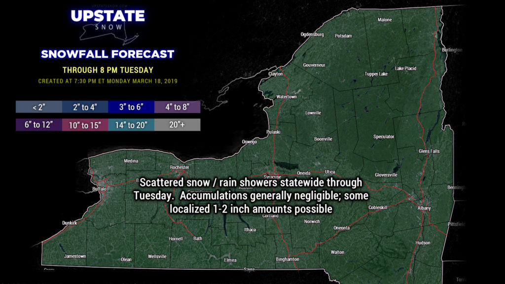
A very active overall “big picture” weather pattern looks to continue. It was originally thought that tomorrow into Wednesday would be quiet and peaceful, but modeling shows a little disturbance dropping across the state Tuesday afternoon. More “convective-style” snow and rain showers are expected across the state… but it’s doubtful that any of this will transition to any meaningful snowfall other than little bits here and there.
Instead of trying to pinpoint where snow showers will end up, we’re going to go with a “generic” kind of snow prediction. Accumulations will generally be negligible through tomorrow evening… but some areas may pick up an inch or two of new accumulation — the higher elevations are the most likely to get accumulations.
The next system moves in Wednesday night. An area of low pressure will dive southward out of Canada and sling a front across the region. This will result in more snow and rain showers late Wednesday night into Thursday. The GFS-FV3 still insists on a storm coming together off the North Carolina coast, on the tail end of this front… and then lifting northeastward into the Gulf of Maine by Friday. We wouldn’t get “synoptic” (general) snows out of this, but it would serve to reinforce colder air diving southeastward across the state. This isn’t much of a leap of faith, because when we look at the highs and lows at the 500-mb level (about 18,000 feet), a deep trough exists over the northeast Friday into early Saturday. Again, the “big picture” is an active one. The Euro also jumps on board with the coastal development…. again, too far off the coast for any “real” snows over the Upstate, but close enough and deep enough that wraparound moisture combined with a reinforced shot of cold air keeps numerous snow showers to the Upstate on Friday. Not a LOT of snow… no “snowstorm” by any means, but we’re sure nobody will mind a few more inches of snow on the Tug Hill.
That moves away for the second half of Saturday, and high pressure builds across the Virginias by Sunday. A southwesterly flow becomes established on Sunday and that will mean quite the warmup… temps Saturday ranging from the upper 20s in the Adirondacks to around 40 / lower 40s for the southern tier — jump into the mid 40s for the ADKs to near 60 across the southern tier on Sunday. Remember, though, the active weather pattern… modeling turns us colder into NEXT week… and it appears that temperatures are going to run, on average, below seasonal norms as we head toward the first of April.
Thanks, as always, for viewing, and we’ll see you tomorrow!


