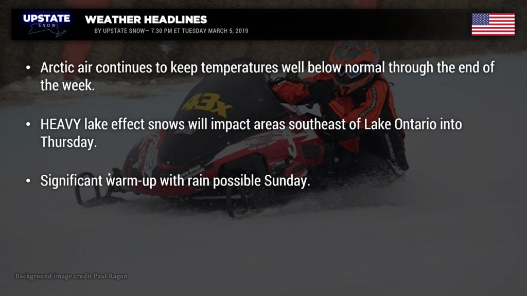
Good evening!
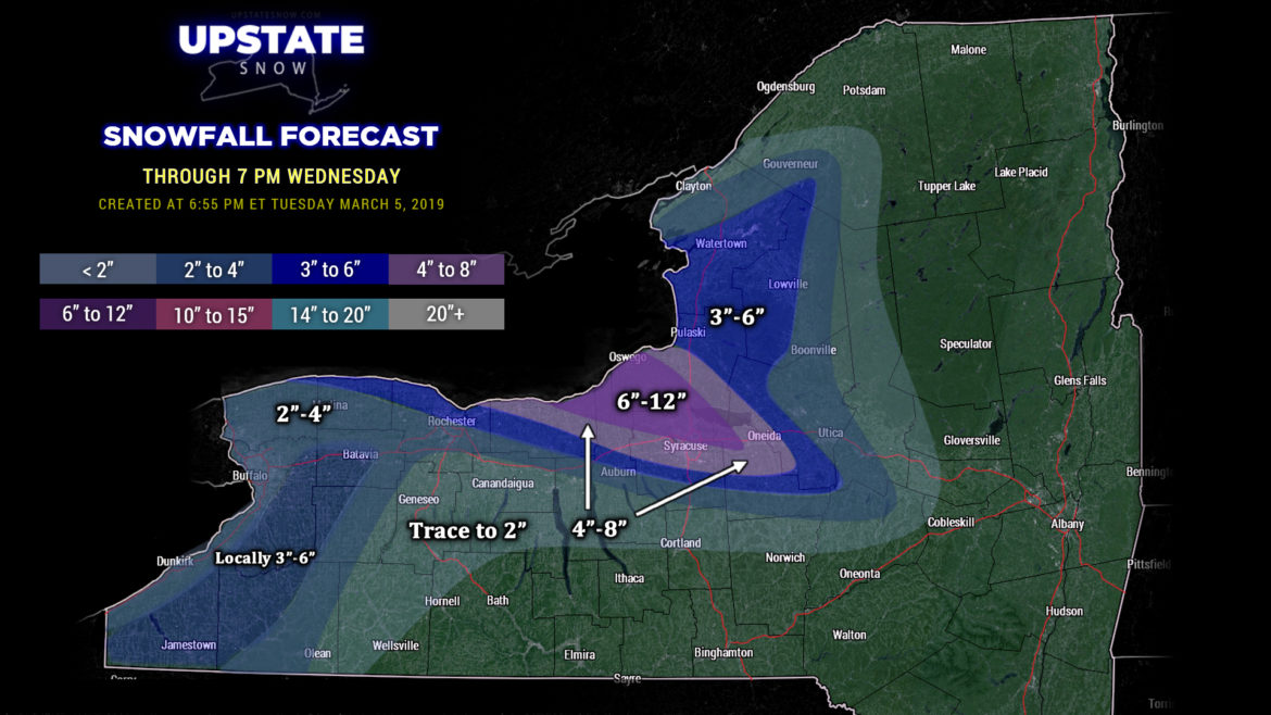
Late-season lake effect snowstorm will persist into Thursday. For the past few evenings we’ve talked about low pressure over northern Ontario spinning down multiple fronts across the state, and that will continue. As of this writing a cold front extends from roughly Toledo, Ohio northeast bisecting Lake Erie, cutting across Lake Ontario and extending northward into eastern Ontario. A band of enhanced lake effect snow is impacting areas including Adams Center, Watertown, Sackets Harbor, essentially following route 11 to the Jefferson/St. Lawrence county line. This band should move southeastward as it gets picked up by the frontal boundary… and will be in the process of doing so as you read this blog. The frontal boundary will work to enhance the moisture as we go through the night, and the band becomes quite focused southeast of Lake Ontario. Modeling shows a very well-defined plume of lake snows to target northern Wayne, northern Cayuga, southern Oswego, northern Onondaga, northwestern Madison, and western/southwestern Oneida counties through the day Wednesday. The heaviest snows are expected to fall in an area including Wolcott, Baldwinsville, North Syracuse, Bridgeport, Central Square, Fulton, Minetto, to Oswego, where upwards of a foot of new snow can be expected through suppertime Wednesday.
That being said… there isn’t 100% certainty with this positioning. I used a blend of all the high-res modeling to come up with the snow total forecast through 7 PM Wednesday. As we know all too well, the actual placement of the band could make-or-break our forecast. Another factor that could bomb our map is the length of time the band stays situated over one particular area. It is possible that some isolated areas could see significantly more snow, while other areas see hardly anything.
I’ve painted a broad area of 3-6 totals over the Tug with a “nose” extending along the Jefferson/Lewis county line into St. Lawrence county to account for the activity that is going on there as well, but again, that activity will come to an end after the front passes, carrying our snow band southward.
NWS has posted Winter Storm Warnings for Wayne, northern Cayuga, Onondaga, Madison, and Oswego counties through tonight. They have issued advisories for all of the lake counties, including off of Lake Erie. Most of the snows that occur off of Lake Erie will be “enhancement” in response to the frontal boundary increasing the available moisture, with the Chautauqua Ridge causing uplift, squeezing out that extra bit of moisture. There’s a lot of ice cover over Lake Erie so there’s not going to be that much direct lake effect—this is going to be more of an “enhancement” thing. We’ve painted a diffuse area where locally 3-6 could fall… it’s not going to be a widespread blanket of that amount.
We probably could have gone with a larger zone of “trace to 2 inches”… possibly drawing the line as far south as Bath and Ithaca to Oneonta, and then curving north… going as far east as Speculator and Tupper Lake before curving up towards Potsdam, but … it’s another case of the amounts being scattered and away from the focus points of this forecast.
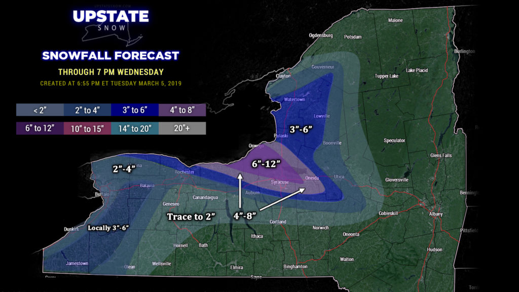
As mentioned, the lake snows continue Wednesday night into Thursday southeast of Lake Ontario. This will be aided and abetted by another one of these fronts zipping through. The forecast becomes fairly difficult at this point as there’s not an awful lot of agreement in our modeling on what this front does to our band. We believe the band will stay together to perform a few of their greatest hits, but where the drummer and lead guitarist set up shop is a bit of a question-mark. The keyboardist and bassist want to go to Syracuse while the rhythm guitar player likes things in Parish. For right now it appears that it will be in a similar location to the setup later tonight and early Wednesday… and if that ends up being the case, one could probably expect an additional 4-8 or 5-10 over the current 6-12 color on the map. Again, we can’t rule out a position farther to the south, i.e., Syracuse… considerable uncertainty here.
Regardless… it should be stressed that the clock is ticking on our season. Bitterly cold Arctic air will remain in place until Friday when things start to warm up a bit. Get out and ride, baby, ride, while you can.
The next “real” weather system approaches the area late Saturday night. Modeling points to very deep, mature low pressure over northern Iowa (GFS says 979 mb low!!) lifting northward over the central Lakes and into Ontario. The model shows much milder air (40s and some 50s) pushing northeastward ahead of this system, with a fairly copious rainfall during the day on Sunday. The FV3 is also on board with this solution, however, keeps a bit of colder air trapped over the Dacks and Cats, thus indicating mixed precip to rain. Honestly, it’s way too soon to hammer out these details… but Sunday looks to be warm and rainy across the state. A cold front blasts across the state Sunday night into Monday, with the lake machines possibly getting turned on once again as cold air pushes in.
Ok, that’s it for tonight. Get out and RIDE!

