
Good evening.
A cold front is pressing into eastern New York as of this writing with an axis of rain/snow moving across north/central NY. There is a brief rest in the precipitation before the lake effect snows will begin to set up. Temperatures will continue to fall tonight… and continue to slowly fall during the day on Monday as well.
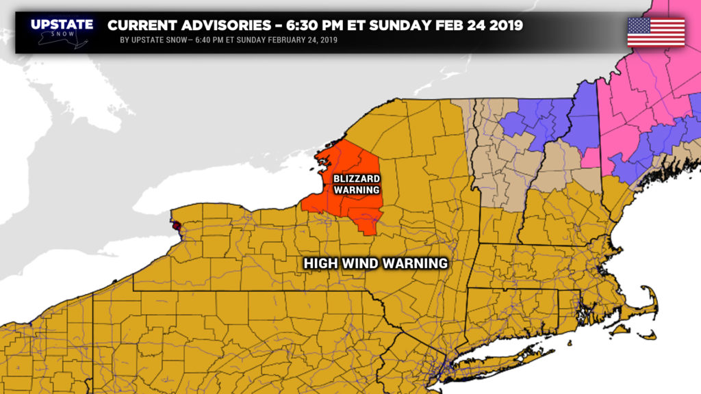
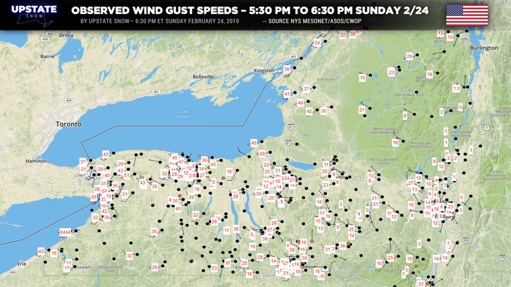
A very strong low pressure center was located north of Lake Huron, and as this low continues to strengthen and lift north/east, wraparound winds will continue to roar across the state… pushing eastward through the rest of the evening. It’s still possible that we see wind gusts pushing 75 mph for a few more hours this evening… peak gusts should “diminish” somewhat to between 60-65 mph… but these winds could last up to 12 hours into Monday morning. It’s obvious that this severe wind event will cause power outages, damage to trees and property, travel disruptions, and eventually blizzard conditions east of Lake Ontario, as we’ve illustrated over the past few evenings. Winds will gradually diminish during the day Monday… and then really drop off after sunset Monday when high pressure starts to build in.
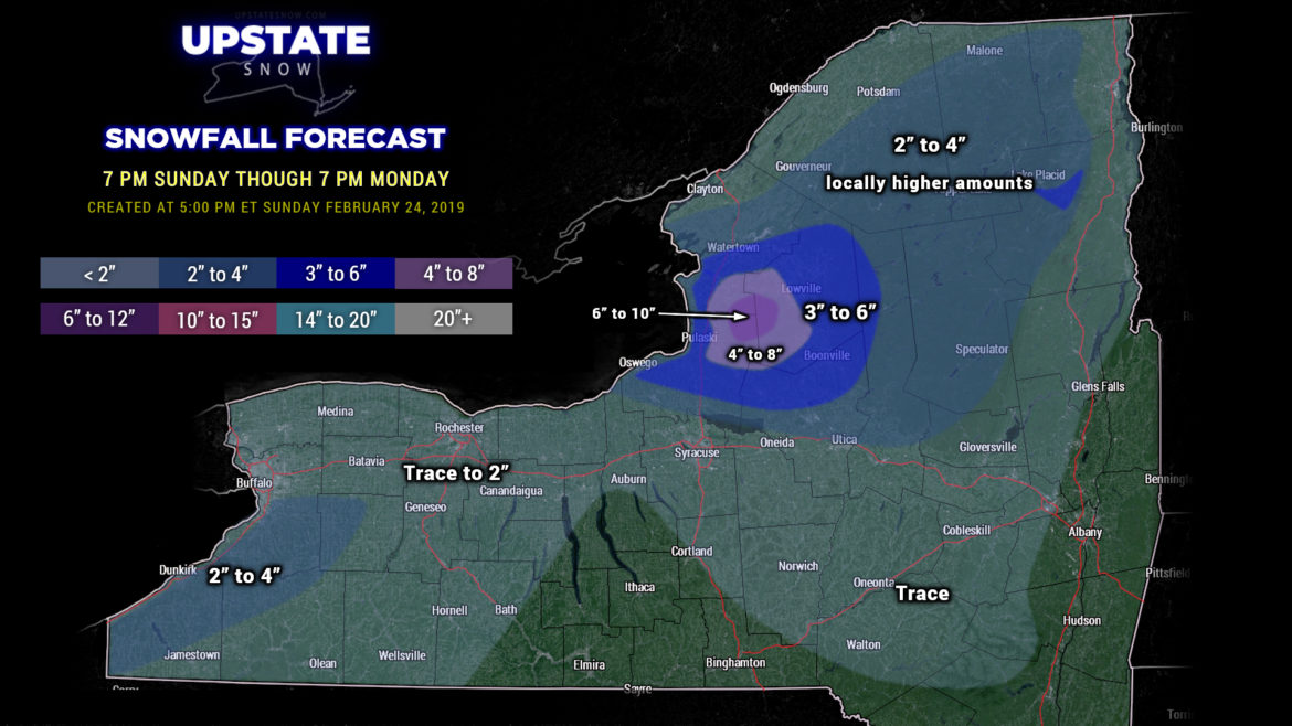
Snow will fall across much of the upstate tonight through Monday, but the accumulations will be focused east of the lakes. Lake Erie won’t have as much “participation” given the significant ice cover… we’ve painted in a generalized 2 to 4 inch color east of Lake Erie. These will be variable amounts, and with the 40-60 mph winds, virtually impossible to measure. The bigger story will be the whiteout conditions and very difficult travel conditions tonight, along with the widespread blowing and drifting.
The true bullseye is east of Lake Ontario. Blizzard warnings are up for Jefferson, Lewis, Oswego, and Oneida counties. Blizzard warnings aren’t issued because of any kind of crazy snow totals… the criteria is “sustained wind or frequent gusts greater than or equal to 35 mph will accompany falling and/or blowing snow to frequently reduce visibility to less than 1/4 mile for three or more hours.” This will … obviously … be the case through the overnight and through Monday afternoon.
The modeling all agree that there will be upstream connections to Georgian Bay and Lake Huron, with extensive inland extent; especially Monday afternoon. We have probably leaned a bit conservative on our snow map with the dark blue 3 to 6 inch totals… it’s probable that the 3-6 inch amounts could extend farther south to the Thruway, impacting Syracuse to Utica, and eastward well into Herkimer county and even Hamilton county. The highest accumulations will be over the Tug, with 6-10 / 6-12 amounts likely. Accumulations are really fairly irrelevant; the bigger story will be the blizzard conditions. Over the blizzard warned counties, winds of 40-65 mph will create widespread whiteout conditions, near-zero visibility, virtually impossible travel conditions, and widespread blowing and drifting of snow. Accumulations will have widespread variability given the wind. Snow totals of 2-4 to possibly 3-6 will extend north and east through the Adirondacks as well, given the current ongoing snows from the storm system being enhanced by the mountains.
Elsewhere, a trace to a couple of inches of snow are expected; the farther away you go from the lakes, the lesser the snows will be.
Lake effect snows will start to slowly wind down Monday night into early Tuesday as high pressure builds in. Tuesday will feature temperatures below seasonal norms… with highs generally in the teens across the majority of CNY, with single digits in the Adirondacks, and temps into the lower 20s from Buffalo to Rochester southward to Jamestown. Temperatures Tuesday night will dip below zero over the Adirondacks, with single digits above zero for most of CNY, and temps in the lower teens from Buffalo to Rochester southward to Jamestown.
Now… as we go through the work week, the next system to bring snows to the area will come on Wednesday as a diffuse little area of low pressure dives southeast over the state. Scattered snow showers are expected, no real major accumulations. Lake effect will set up again behind this system for Wednesday night into Thursday, but at this point it doesn’t look like this will be anything to get excited about as well.
As we flip the calendar to March, modeling shows another fairly significant storm system taking aim on the northeast next weekend… with some of the guidance suggesting the low track(s) will be fairly similar to the past few storm systems that have rolled through here.

