DAMAGING TO POTENTIALLY DESTRUCTIVE WINDS SET TO IMPACT MUCH OF WESTERN AND CENTRAL NEW YORK.
BLIZZARD CONDITIONS TO IMPACT THE TUG HILL.

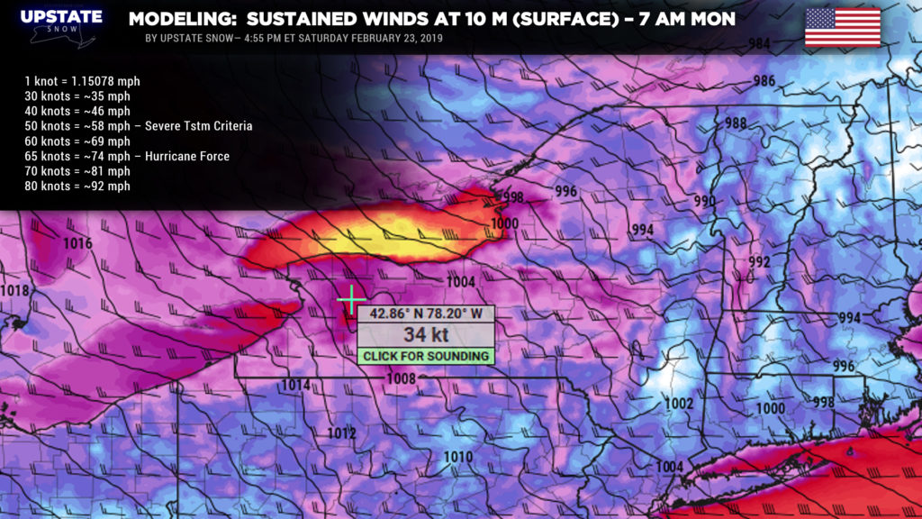
Yeah… it’s going to be a bit breezy…
Good evening everyone…
Ok the game is on now. A pair of storm systems … one to our west/north, one off the coast, will lift northeastward tonight through Sunday into Sunday night bringing rain, patchy freezing rain, two rounds of very gusty winds, and blizzard conditions with lake effect snow through Monday.
Rain showers will break out from southwest to northeast tonight. Some freezing rain showers will take place over the Catskills and the Adirondacks as cold air tries to hang tough, and winter weather advisories are up for that purpose. No snow accumulation through the overnight. The rain will dissipate early Sunday morning, and some areas of sunshine are likely as a low-level jet forms over the area. With this sunshine look for temperatures to spike into the 50s. Also, this jet will represent the first round of gusty winds. We posted a GIF on the Facebook page of the modeled wind profile, and if you look carefully you see this early morning “wave” of winds. We’re looking at sustained winds 20-35 mph with gusts to around 50 mph, especially along the Lake Erie shoreline.
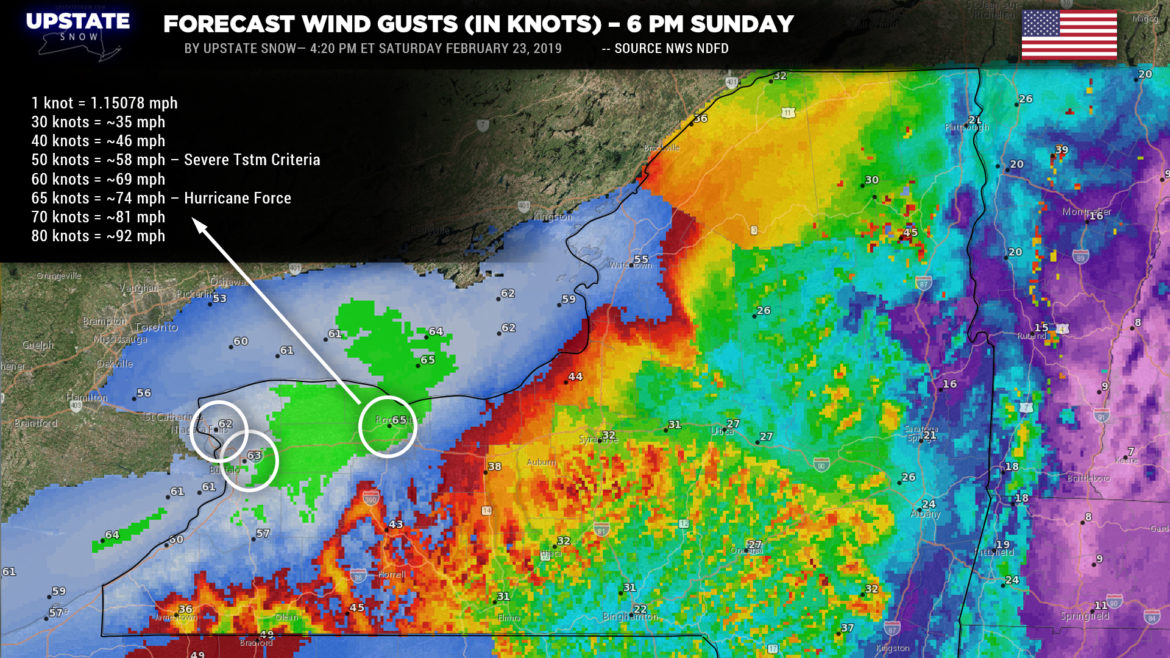
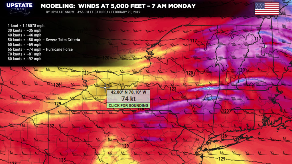
But those are mere breezes compared to what’s headed our way later Sunday into Sunday night and Monday. A cold front will bulldoze its way across the state during the day. Crazy strong southwest winds will accompany the front. At 5,000 feet, these sustained winds will be screaming between 70 and 80 knots (which is between 81 and 92 mph). At the surface, sustained winds of 35 to 45 mph are likely… and by Sunday afternoon, some areas may be looking at hurricane force wind gusts to 75 mph.
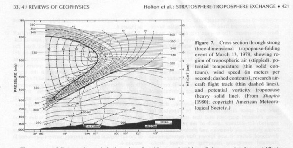
Some interesting science behind all of this — something that doesn’t happen very often, but we are looking at something called a “tropopause folding event.” We live in the troposphere; the tropopause is the “demarcation line” between the troposphere and stratosphere, which lies above. Strong, deep cold air will be pushing in from the west/northwest behind the front. This will cause the “lapse rate” (the rate at which temperature falls as you go from the surface upward) to become very steep — a very sharp, rapid decline in temps with height, which indicates that stratospheric air is pushing much closer to the surface than one would normally expect (usually the tropopause lies between 25,000 and 65,000 feet, but in this case may drop as low as 15,000-18,000 feet). This creates a “squeeze” which the atmosphere wants to resolve, and it does so by … making it windy. I attached a picture from a textbook that illustrates the definition of a tropopause fold.
At any rate, we’re looking at a 8- to 12-hour period of damaging to potentially destructive winds. Nearly the entire state is under a High Wind Warning Sunday afternoon into Monday. The highest winds will be over the lake plains, with, again, gusts to 75 mph. Gusts to 55-65 mph are likely for much of CNY and the Adirondacks. While the highest gusts should die down a bit during the night Sunday night, as you can see from the model maps posted above, strong SUSTAINED winds are likely to continue into Monday. As per NWS Buffalo, “these strong wind gusts will bring down numerous trees and power lines and result in widespread power outages. Power may be out for several days in some areas. Shallow rooted pines will be particularly vulnerable. Property damage is also likely, especially to roofs and siding. Buildings under construction and old deteriorating buildings may be damaged significantly. Travel in high profile vehicles will be very difficult at times, and empty tractor trailers may be in danger of being blown off the road.”
STORM WARNINGS FOR LAKE ONTARIO AND LAKE ERIE: Winds to 50 knots (58 mph) will create waves of 23-28 feet over the open waters.
LAKESHORE FLOODING: Powerful southwest winds will gust up to 75 mph. This will result in the water level at Buffalo rising to 9 to 11 feet above low water level. This rise will also break up ice on Lake Erie and result in significant ice movement. Lakeshore flooding is expected along the Lake Erie shoreline, including the Buffalo Harbor and waterfront. If water levels exceed 10 feet above low water datum flooding may occur in the Old First Ward section of Buffalo and at Canalside. Rising waters will also push ice chunks onshore, potentially damaging structures. Ice will also get pushed across the ice boom and into the Upper Niagara River resulting in damage along the Upper Niagara River shoreline. The ice may dam up at river outlets and result in flooding near river mouths.
Off of Lake Ontario — Powerful southwest winds will gust up to 75 mph late Sunday afternoon and Sunday night. Winds of this magnitude will result in significant wave action, along with water rises and ice movement on the eastern end of Lake Ontario. The combination of water rises and extreme wave action will result in lakeshore flooding. Some locations which tend to be vulnerable are Sandy Pond, Black River Bay, Chaumont Bay, and the Thousand Islands Region of the Saint Lawrence River. There is ice in place across northeastern Lake Ontario extending to the Saint Lawrence River. It is likely that higher lake levels and waves will break up the ice. Ice blocks will get pushed onshore and may result in damage to shoreline structures.
BLIZZARD WARNING for Jefferson, Oswego, and Lewis counties: Blizzard conditions and lake effect snows will develop Sunday night through Monday. Our snow map doesn’t extend past 7 PM Sunday, but confidence is good on at least 4-8 inches of snow for the Tug, with 3-6 inches in the lower elevations. That’s not all that much… but when you combine that with 30-50 mph sustained winds, and gusts to 70+, even Stevie Wonder can see the whiteout conditions that will occur. Obviously travel in the lake bands will be nearly impossible. At the onset, the Lake Ontario snows will impact Jefferson County to the northern Tug. As the winds shift from WSW to W to WNW, look for our band to drop southward over the Tug and then to the southern Tug as we get into Monday morning. Again, the intensity (and accumulations) aren’t the big story here — it’s the wind and blizzard / whiteout conditions.
Snows off of Lake Erie won’t be nearly as intense given the large amount of ice cover. However, some “banding” from Lake Michigan may help enhance whatever does come off of Erie, and this will be further enhanced by upsloping with the Chautauqua Ridge. Winds of 30-50 mph with gusts 60-70 mph will mean localized whiteout conditions in this area as well, but probably not producing blizzard conditions for 3 hours or more (the criteria required for a blizzard warning). Actual accumulations are expected to only be “advisory level.”
Again, our snow map only goes out to 7 PM Sunday, and the brunt of the lake effect in both areas will take place after this period.
The lake effect snows should taper off and end by Monday night as surface high pressure builds in.
Given that the primary focus of tonight’s post is this current wind storm, no work has been done looking at the ended period into next week other than a quick glimpse at models showing maybe some light snows in here on Wednesday.
Folks… cannot stress this enough: Be safe, be smart, stay indoors. Preparations for power outages and wind damage should be rushed to completion early Sunday. Take care…

