Good evening…
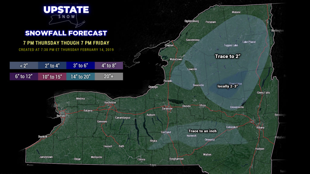
Quiet weather will give way to our next weather system tomorrow. An area of low pressure will move north from northern Michigan into Ontario and Quebec through the day Friday. A warm front will lift off to the north to around the Canadian border. A deep southerly flow of unseasonably warm air will be over much of the Upstate. This low center will strengthen through the day, but the precipitation over the state should, for the most part, be fairly light. Precipitation develops across the state in the pre-dawn hours. This should be in the form of snow in the central/southern Adirondacks. Most areas go over to rain showers through the day Friday before a cold front sweeps across the state and transitions whatever is left back to snow. Modeling … numerous models … show a better chance for accumulating snows in the central/southern Adirondacks, so we’re going with that. The majority of the snow will accumulate before the transition to rain in many areas, so expect melting obviously, but then a renewed trace to maybe an inch of new snow in the late afternoon into the evening, depending on where you are.
Colder air will wrap in behind the system Friday night and set up a bit of a lake response off of Ontario but accumulations won’t be anything to get excited about.
The strengthening storm system will bring some gusty winds to the western part of the state during the day. A Wind Advisory is posted for Friday for a couple of our counties – Jefferson, Niagara, Orleans, Erie, Genesee, and Chautauqua counties. Winds 20-30 mph with gusts to 50 mph are possible in these areas.
For the weekend, Saturday features mainly dry conditions… perhaps some lake snow showers from Ontario and maybe even the Fingerlakes, but not amounting to an awful lot. On Sunday a system slides to our south, and may bring some rain or snow showers to the southern tier Sunday afternoon, transitioning to some light snows Sunday night.
Then the focus turns on next week… next Tuesday/Wednesday… as modeling shows another potentially significant storm with an area of low pressure lifting just to our west with a second low possibly on the coast. Solutions are all over the place, and this far out, no definitive forecast can be offered. Equal chances of rain, mixed precip, or snow at this juncture.
Take care, thanks for viewing, and have a great Friday!


