Good evening….
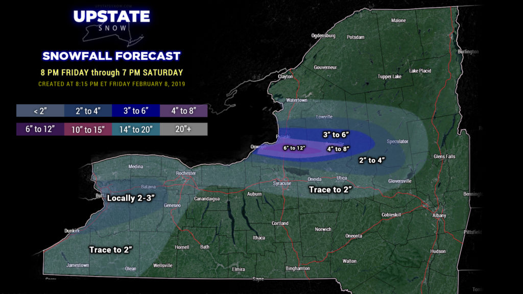
A cold front has formed and is enhancing lake effect snows east of Lake Ontario… impacting portions of Oswego, Lewis, Oneida, and Herkimer counties through the night. This is producing snowfall rates higher than originally anticipated… therefore we are painting a “bullseye” of an additional 6-12 for central Oswego into northern Oneida counties, with a wider area of 4-8 and 3-6 extending outwards. Radar also shows persistent snow showers northeast of Lake Erie; we’re going to paint in a trace to 2 with “locally 2 to 3” for that area. Elsewhere, scattered snow showers will gradually diminish overnight as high pressure builds in.
Wind advisories remain up for a large portion of the state into Saturday… with sustained winds 25-35 mph expected, and occasional gusts to 45 mph possible. This will continue to keep a threat for localized power outages and tree damage going through the night. These winds will also produce a good bit of blowing and drifting snow overnight, and whiteout conditions in the lake effect plume… borderline “blizzard” conditions.
Saturday afternoon through Sunday appear to be dry and seasonable at this time. An area of snow showers will zip across the upstate Sunday night into early Monday, but this isn’t going to amount to a whole lot.
We still are watching the Tuesday-Wednesday timeframe for a potential significant storm. As predicted, models have flopped again. They still show a “double-barrelled” system — one area of low pressure lifting north from Iowa/Illinois through Michigan and into Ontario…. with another wave forming now off the Jersey coast. Guidance is warmer, as they believe the system to our west will be stronger… instead of a transfer of energy to the coast. This solution brings snow to mix… to widespread rain across the area Tuesday into Wednesday. Since this is a complete change in direction from last night, we’re going to continue to “wait-and-see” what our modeling shows over the weekend. Either way, colder air will return behind the system with a lake response.
The key point tonight is the plume of snow off of Lake Ontario and the gusty winds. This will create very difficult travel conditions on the Thruway, possibly as far south as route 20. Be safe if you have to venture out overnight into this area.
Have a good evening, and thank you for viewing!


