Good afternoon/evening…
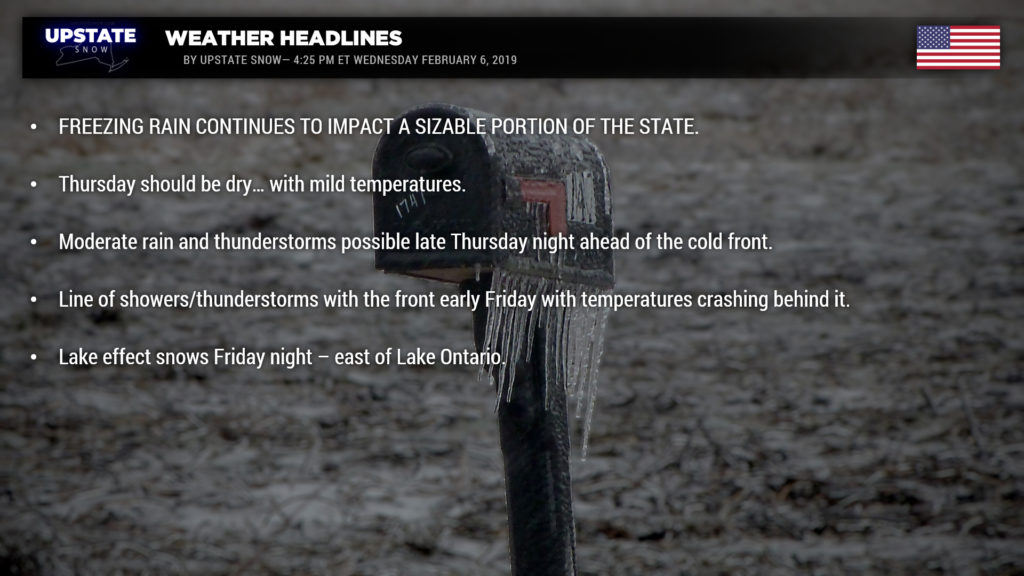
What a mess. Rain and areas of freezing rain over the state as of this writing… some areas are really taking a beating. And of course the modeling underperformed this, a much wider coverage of precip this afternoon.
Winter Wx Advisories still up for a large portion of the state as areas of freezing rain are expected to continue through the night. Sub-freezing temps still exist in the North Country, with temps in the lower 30s for the Susquehanna Region and Catskills. Solidly above freezing as you head west of I-81, the Fingerlakes and SW NY… but 32 at Buffalo and 34 at Rochester (as of 3:48 PM).
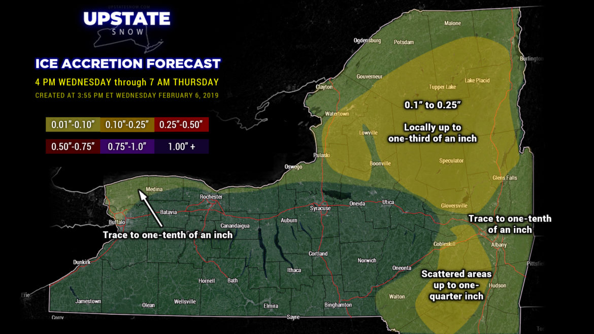
Since temperatures are running below freezing, and since we have a much higher coverage of precipitation, obviously there will be a higher ice accumulation total, especially in the North Country and portions of the Catskills. Making a map to delineate this is tough because a one-degree difference means cold rain vs freezing rain. It is with that disclaimer that we produce a rather “medium confidence” ice accretion map:
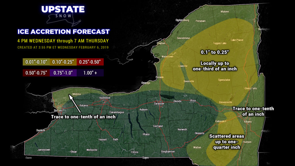
We think the highest icing totals will still extend from Watertown and the Tug eastward through the Adirondacks… at this point up to a quarter of an inch of icing… maybe some isolated areas seeing a third of an inch of icing… by early Thursday morning. Portions of the Catskills also possibly looking at up to a quarter-inch of ice. In drawing the map, we essentially followed the terrain. Not “everyone” will see these totals… and yet again some may see even more. Drop us some pics in the comment box on the Facebook post, along with your location and time the pic was taken!
Warmer air is going to push northeast across the state. It’s just a little slow in doing so. Our temperatures will likely continue to rise during the night and nearly everyone will be above freezing by time you sit down to breakfast on Thursday. The last hold-outs, oddly enough, look to be along the southern shores of Lake Ontario and north/west of route 11 to Potsdam, and then northward to Massena and Cornwall Island. That is… if you believe the high-res modeling (both the HRRR and NAM3k). (Said with some sarcasm.)
Now if we still believe in our high-res modeling, much of the day Thursday will be dry. Another unseasonably mild day with highs into the upper 50s / flirting with 60 for much of the western part of the state… mid 40s just about everywhere else south of the Thruway, and around 40 for the North Country. But again… dry.
The next… and final… “wave” of precipitation lifts north and east across the state Thursday night as a strong area of low pressure shoves northward through the Great Lakes into Ontario. There is an abundance of moisture with this. As we’ve seen this season, these storms that rocket up to our north and west have been fairly significant rainmakers, and honestly, I don’t see much of a reason to think this is going to be any different. So a rainy Thursday night is in store… and there may be enough instability that some thunderstorm activity is possible as well late in the overnight. Rainfall could approach an inch in some areas.
Modeling is now showing that our kicker cold front will push through the state earlier in the day… pushing east of the state during the early afternoon. Modeling suggests almost a “convective line” along the front… again the potential for thunderstorm activity. Temperatures will absolutely tumble after the frontal passage… whatever rain is still falling will quickly switch over to snow.
It’s not unreasonable to expect an inch or so of snowfall in the immediate aftermath of the front… but any remaining water will freeze up Friday night as temperatures drop. Gusty winds develop… as does lake effect snow. There’s a good bit of ice on Lake Erie, so the real target for LES will be Lake Ontario Friday night… expect a plume or some bands to form east of the lake in the usual suspect area… it’s too early to really call, but we’ll give a ballpark guesstimate of 4-8 for the Tug.
Dry weather will prevail over the weekend, with seasonable temperatures. At first we thought there would be some light snows Sunday afternoon or Sunday night… meh… that’s questionable. Either way it doesn’t look like it would add up to anything noteworthy.
A quick glance at modeling for NEXT week shows the potential for some snow showers / light snows on Monday… followed by another significant system for midweek. There’s about a 500-mile distance between the modeling as to placement of the low… either a perfect Nor’easter dumping buckets of snow on us… or lifting north through Wisconsin and Michigan with another drenching rainfall. Stand by…
Hey… any photographers in our group? If you have some great snow pics or sled pics or anything along those lines, send us a message on the FB page… we’d love to update our slide background graphics. (Full credit will be displayed on the slide.)
Have a SAFE evening, and we’ll catch you tomorrow.

