Jefferson-Lewis-
609 PM EST WED JAN 30 2019
…A BAND OF LAKE EFFECT SNOW WILL AFFECT JEFFERSON AND LEWIS COUNTIES…
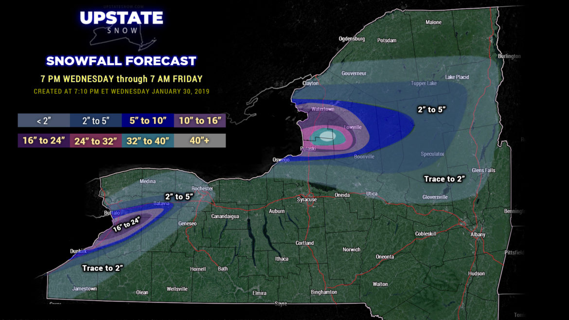
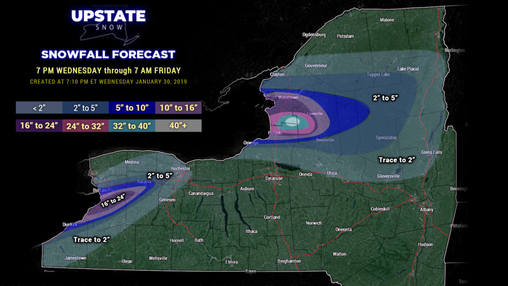
At 605 PM EST, a band of lake effect snow producing snow fall rates of 2 to 3 inches per hour continues from Cape Vincent east to Harrisville. This band is expected to slowly drift further south during between 6 and 8 PM this evening. Meanwhile, a second band to the south near Adams is drifting north and merging with the stronger band over the Black River Valley. Both bands will continue to edge closer to each other with a single intense band from Watertown east later this evening. This will produce blizzard conditions with frequent whiteouts. This will create a dangerous situation for anyone on both primary and secondary roadways.
Meanwhile, temperatures are only a few degrees above zero and will drop below zero this evening. This together with increasing winds, will create windchills that will drop to 25 below zero. As a result, spending only short periods of time outside may lead to a life threatening situation without proper winter gear.
Locations impacted include…
Watertown, Fort Drum, Stony Point, Carthage, Lowville, West Carthage, Adams, Dexter, Glen Park, Herrings, Adams Center, Henderson Harbor, Barnes Corners, Denmark, New Bremen, Watson and Sackets Harbor.
Southern Erie-Wyoming-Genesee-Niagara-Northern Erie-
602 PM EST WED JAN 30 2019
…A BAND OF LAKE EFFECT SNOW WILL AFFECT NORTHERN WYOMING…ERIE… SOUTHEASTERN NIAGARA AND GENESEE COUNTIES…
At 557 PM EST, two bands of lake effect snow are producing snow fall rates of up to 2 inches per hour along with visibilities near zero. Temperatures are near or below zero with wind chills near 25 degrees below zero.
…THIS IS A PARTICULARLY DANGEROUS SITUATION…
Blinding snow and whiteout conditions are occurring. A casual drive or trip outside can quickly lead to a life threatening situation without proper winter gear. Please heed all travel bans.
Two separate bands are occuring east of Lake Erie. One is over Buffalo and edging into the Northtowns east past Batavia. A second and stronger band extends near Dunkirk to the Boston Hills, the Southtowns, and into far northwest Wyoming County. These bands are converging over Genesee County and are producing whiteout conditions there as well. These bands will move a little to the north between 6 PM and 8 PM. Meanwhile, temperatures will continue to drop below zero while wind gusts exceed 35 mph at times, producing blizzard conditions at times along with dangerous wind chills.
Locations impacted include…
Buffalo, Cheektowaga, West Seneca, North Tonawanda, Clarence, Lackawanna, Batavia, Kenmore, Depew, Amherst, Tonawanda, Lancaster, Hamburg, East Aurora, Williamsville, Darien Lakes State Park, Grand Island, Evans, Elma and Boston.
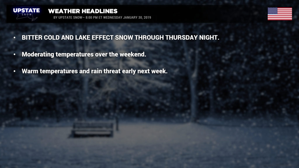
Wind chill warnings remain posted through Thursday. Wind chills will be around 30 below zero… if not even colder. Look for actual temperatures when you get up tomorrow morning to be ranging from around 20 below in the North Country to between zero and 10 below along and south of the Thruway. Highs tomorrow will rise to around zero in the North Country to between zero and 10 above elsewhere… lower teens in the Capital District and down the Hudson valley.
An absolutely stupendous amount of snow for the Tug Hill through early Friday morning. As noted, Blizzard Warnings are up for the hardest hit counties off the lakes… you don’t need us to say that it will be very dangerous to be outside tonight. The Blizzard Warnings will likely be “downgraded” to Winter Storm Warnings by Thursday morning. The lake snows will continue into Thursday evening… high pressure will start to ridge toward NY late Thursday night which will put the lake plumes on life support … they’ll eventually become disorganized and die. The surface high really takes control on Friday, shifting off to our east Friday night and Saturday. This sets up a return flow of air from a southwesterly direction this weekend.
Things go downhill fast early next week. Low pressure organizing over the upper midwest… Nebraska to Iowa… will lift into Minnesota. Normally you’d think, “yeah, so what.” Well… it’s going to sling a very elongated warm front over the state late Sunday night. This front looks like it will make it about as far north as the Canadian border before stalling. The front itself shouldn’t be all that remarkable… maybe some light snow or light mixed precipitation… but it will open the doors to allow unseasonably warm air to pump northward.
How warm? Looking at widespread highs in the 40s for all areas, including the North Country, on Monday… with some 50s possible for Buffalo and Rochester. Similar temps look likely on Tuesday…. with perhaps even more widespread 50s over the Southern Tier.
At the same time the aforementioned low will move well to our west and north bringing the threat for rain. At this early juncture the models are somewhat disagreeable on just how much rain, but it will definitely be warm enough. This looks like it will be a fairly robust low but the saving grace may be its distance from us. If the modeling shifts eastward over time we will definitely need to watch out for increased rain threat…. and an increased flooding threat.
Again… tonight… don’t venture outdoors. Just… don’t. Stay home, stay safe. Thanks for viewing and take care!

