LAKE EFFECT BOMBARDMENT AND BITTER COLD WIND CHILLS.
Good evening!
Two big things to talk about: The bitter cold… and the lake effect snow.
Right now “general” snow continues across much of central and eastern New York from our storm system and Arctic front. As of 5 PM the front bisected the state from roughly Malone through Sullivan County, and low pressure was centered over Philadelphia. Snows continue to fall, locally moderate to heavy at times. This will continue to push east through the evening. A second Arctic front will cross the state Wednesday.
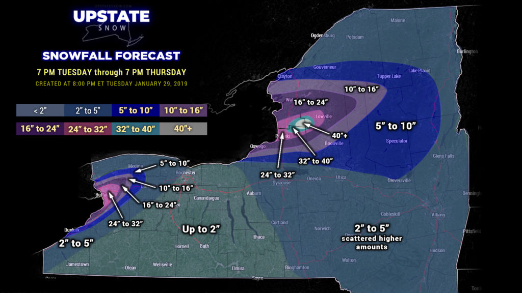
Conditions are PERFECT for tremendous lake effect snows…. initially focused right over the city of Buffalo, and then east off of Lake Ontario.
For tonight, the Lake Erie plume will become established over Buffalo… with over 2 feet of snow expected for the city… with a fairly rapid drop-off as you move away from the plume. This snow will continue through Thursday, and the band isn’t likely to waver much at all during this time.
Lake Ontario comes ALIVE early Wednesday initially in a WSW-to-ENE orientation into Wednesday evening, then shifting southward and absolutely obliterating the Tug Hill. A perfect flow of wind over that wide open water will result in at least 3 feet of new snow in the typical area… probably north of 40 inches, with amounts decreasing as you move away from the plume.
Here is our snow map. We’ve adjusted our color table given the absolute ridiculous amount of snow expected. The map is effective through 7 PM Thursday.

BITTER COLD TEMPERATURES: Wind Chill Warnings are up for portions of the state thanks to gusty winds and plummeting temperatures. Most of the state will likely not go above zero on Wednesday… and we’re going WELL BELOW ZERO Wednesday night. The gusty winds (20-30+ mph at times) will make it feel like it’s 30 to 45 below zero. Folks this is DANGEROUS cold. Bitterly cold temperatures continue Thursday and Thursday night as well.
The lake effect bomb will gradually come to an end Friday as our winds shift and surface high pressure builds across the area… but some scattered snow showers will remain.
That’s it for tonight folks, focused on the lake effect and cold. We’ll cover the potential for a warmup and rain into next week with tomorrow evening’s report. Be safe, especially traveling — whiteout conditions are likely in the lake plumes, and with the cold. Be smart. Thanks for viewing!!


