Hi everyone…
THE GOOD THE BAD AND THE UGLY
We’ll save the good stuff for later… going in reverse order and getting the other stuff out of the way…
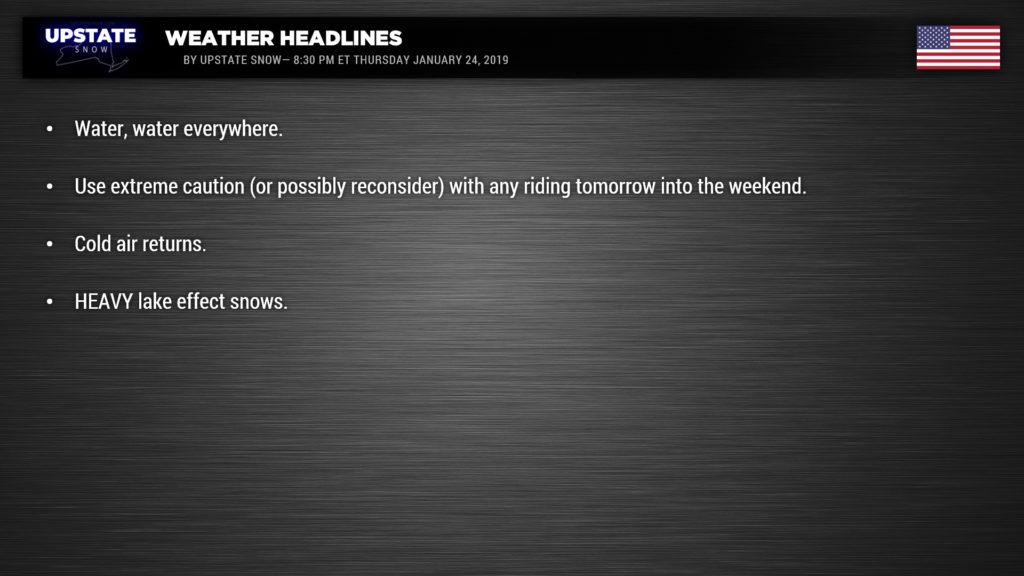
THE UGLY: The 2 to 3+ inches of rain. The modeling underperformed, and so did our forecast. If it wasn’t for the snowstorm last weekend and the bitter cold up until yesterday, this could have been a wipeout storm. There is WATER, WATER EVERYWHERE! Many roads and streams have flooded… as for trails from deep in the Adirondacks to the Tug to everywhere else, there is water, water everywhere. In the short term, it’s bad. It’s going to take a few days to get back up after this swift kick to the face
THE BAD: If you had plans to ride tomorrow, we ask you to reconsider. Some of our team members were going to ride but we are not. This water needs time to settle down and run off, the incoming cold needs time to start refreezing things back up… and give the hard working volunteers from the clubs time to help get the trails back in shape. If anything, they could sure use a hand!
If you planned to ride this weekend: Use extreme caution. Though it will be cold and lake effect snow around, it can hide trouble. Don’t expect great conditions. Be careful and take it slow. Support the clubs and businesses any way you can… please don’t complain. They are frustrated too.
If you planned to run any of the lakes: We ask you not to this weekend. Give it time. All that rain is going to change lake levels, cause pressure ridges, slush, broken shore ice and all kinds of hidden dangers. It should be much better and not as dangerous to run lakes later next week.
THE GOOD: The fact that we still have a base on the Tug and in the ADKs to work with… and even parts of CNY, ENY, the Southern Tier and WNY could get back online in the coming days with some snow and cold. Speaking of lake effect snow and cold, we got a lot to talk about!
Winter Storm Warnings are up for areas east of Lake Erie (through 7 AM Saturday) and east of Lake Ontario (through 10 AM Saturday).
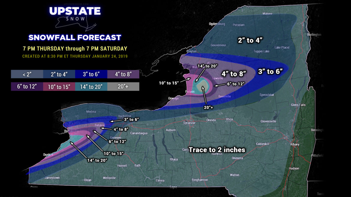
An area of low pressure will move from Lake Superior up the St. Lawrence valley through Friday. This will sling a cold front across Lake Erie during the overnight. Winds will become just south of west (from roughly 8:30 if you’re looking at the hour hand on a clock face) and models show a band of LES pounding the Lake Erie shoreline… mostly impacting Erie County… but intense snows may also impact northern Chautauqua county, western Wyoming County, and southwestern Genesee County. Heavy LES will impact the city of Buffalo by early Friday morning. As the front pushes farther to the east look for the band to start to push southward to impact Orchard Park, East Aurora, Angola, eventually Dunkirk. Travel on I-90 and US-20 along the Lake Erie shoreline will be extremely difficult during the day Friday.
Meanwhile, this front will also be crossing Lake Ontario and should move ashore Friday morning. That 8:30-o’clock orientation becomes established, and the cannons fire. Heavy lake snows will impact portions of Jefferson, Lewis, and Oswego counties… upsloping along the western edge of the Tug Hill will enhance the snowfall intensity… and it wouldn’t be surprising to hear a rumble or two of thunder around noontime.
This front will continue to cross the state and kick off scattered to numerous snow showers everywhere else… so most everyone should get SOME new snow accumulation out of this.
But wait… there’s more…
A second boundary will drop down over northern New York during the afternoon hours. This will allow very cold air to pour southward across the state and further enhance the lake snows. The Tug sits squarely in the crosshairs as the band (or bands or one large plume) pours eastward off of Lake Ontario.
Meanwhile the Lake Erie activity will continue to target the Southtowns.
It will be fairly windy across the state on Friday thanks to these two frontal boundaries — so an abundance of blowing and drifting will take place, especially in the lake plumes… and travel in these areas is going to be extremely difficult with localized whiteouts.
Our lake storm continues into Friday night and Saturday. The Lake Erie plume looks like it will slowly drift back to the north, back toward the Buffalo area proper during the night, and then kind of gently “winshield-wiper” during the night. The wind flow shifts early Saturday and the Lake Erie storm will quickly come to an end at that point.
Lake Ontario, though… Friday’s activity is just the warm-up act. The Tug will be absolutely pounded Friday night into early Saturday… and it really doesn’t look like this band is going to really move in any particular direction (we don’t anticipate any kind of “windshield-wiper” effect with this one). This band should primarily impact Lewis, Jefferson, and Oswego counties, perhaps the extreme northern portion of Oneida county. As our winds shift on Saturday, this band will very quickly fall apart, ending the storm there as well.

Blah-blah-blah, “Dude, how much snow???” A LOT. We’re going with a 48-hour map tonight, through 7 PM Saturday, and our color scheme is maxed over the Tug. There will be fairly sharp cut-off lines, and, as is typical with lake effect snows, not everyone in these bands will pick up the “top” amount. Again, the Tug wins this with 20+.
For the rest of the state, Saturday should feature quiet weather with seasonably cold temperatures. A very weak little disturbance will keep skies on the mostly cloudy side.
Longer term… roller-coaster rides. Shots of very deep Arctic air will drop down over the state… but models show yet another storm system moving just to our west Monday night into Tuesday… which could bring in a brief shot of warmer air and the chance for rain. At this juncture it doesn’t look very strong, but it’s there and … as we’ve seen this season so far, storms moving to our west/north have been devastating to us. However, looking at overall trends, the pattern going into February shows a very high probability that temperatures go below seasonal norms… and stay that way. And that… is good.

