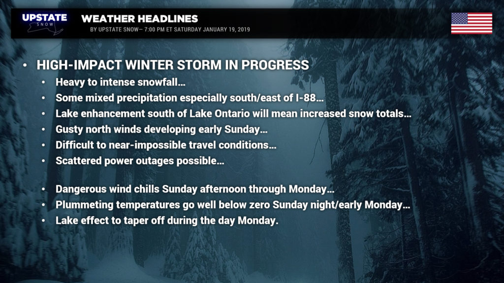
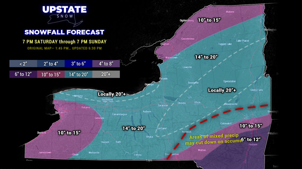
Hi everyone, our storm is upon us now. The latest runs of the short-term / high-res models paint some mixed precip as far north as Binghamton to roughly Norwich, Richfield Springs, eastward to Amsterdam into southern Saratoga County. IF… IF this occurs, it would cut down on the overall snow totals and add misery to the overall situation. The trend has occurred over the past couple runs of the HRRR model so… ugh… we’re going to make note of it, but not make any whole-scale changes from the map we posted on Facebook earlier today. We just added a line indicating where this mix MAY occur, and a note that mixing will cut down on accumulations in those areas.
A deformation zone/band is still expected to become established over central to northeastern New York during the overnight. THIS IS NOT A CERTAINTY… but if it does come together as the RGEM model points out, watch out… LOCALIZED snow totals could go much higher than shown on the map. You might also experience some thunder and lightning… quick… someone get Cantore on the phone!
Winds will become northerly early on Sunday. As temperatures nosedive, great instability will occur over Lake Ontario, and the southern shoreline will likely get rocked with overall storm totals approaching 2 feet. Again, it’s impossible to pin down exactly where, but be ready for that.
For everyone else, our confidence is high on between 10 and 20 inches of snow.
Plain and simple… no unnecessary travel tonight or tomorrow. Some counties have actually issued formal advisories stating this. Unless it’s a true life-or-death emergency, just stay home and stay warm. As mentioned, the winds turn northerly early Sunday and increase throughout the day. Winds of 20-30 mph will create WIDESPREAD blowing and drifting snow, and near-whiteout conditions in many areas. It wouldn’t be surprising if there are scattered power outages as well. Gusty winds will continue Sunday night and finally relax a bit by Monday afternoon.
The lake effect snows south of Lake Ontario will probably continue into Sunday night. As we get into Monday, winds will become more northwesterly, establishing an area of lake effect southeast of the lake… Wayne, Cayuga, Oswego, Onondaga, probably Oneida and Madison counties as well.
Oh, and it’s gonna get COLD… like BRUTALLY COLD. The Arctic floodgates open up Sunday with temps falling throughout the day… and by time you get up on Monday morning, look for air temperatures around 20 below zero for the North Country, zero to 10 below south of the Thruway. Wind chills 30 to 45 below zero likely. Certainly not going to rebound much during the day…. single digits above zero south of the Thruway, with single digits below zero to the north.
Don’t venture out tonight, unless again it is a life-or-death situation. Venturing out on Sunday probably isn’t in your best interest either given the dangerous road conditions, winds, drifting, wind chills, etc., etc. We know you’ll want to ride… lets let the storm wind down first.
We’re entering a fairly active weather pattern going through next week. Models are coming in line with a brief warmup on Wednesday (above freezing) as a storm system moves just to our west… but with the possibility of low pressure developing just off the Jersey coast on the trailing cold front….. an assortment of precipitation is looking more and more likely for Wednesday-Thursday timeframe…
At any rate, stay home, stay warm, stay safe.


